

Oops! How did I miss publishing this post on Death Valley? Oh well, I goofed and here it is!
“Did you know Death Valley is almost the exact same size as the state of Connecticut?”
That was the question posed to me by the Park Ranger as I picked up my park map and newspaper at the Furnace Creek Visitor’s Center, and no, I did not know that. What I do know, is that is where the similarities end. Death Valley is the largest National Park in the lower 48 states. It has several distinct regions, and it’s a long drive between them through very dry, very hot desert. with fuel available only at usury prices, so be sure to fill up before you head into the valley because you’re going to want to see as much of this place as possible in the short time you’ll have before the desert claims all the moisture in your body and your eyeballs begin to dry out (I’m not kidding.) I arrived late afternoon and after a beautiful night with stars from one end of the horizon to the other, here’s what I was able to fit in.
A drive to Dante’s View.
From the main road, this is a 13 mile (one way) drive up a paved road that gets increasingly narrow, windy, and steep with the last portion on a 15% grade. The reward is a spectacular, with a panoramic view of the Badwater Basin and the Panamint Range. From here you can see where the Basin and Range region is spreading apart. This was once a lake bed, but split along a fault line with one side moving upwards to form the Amargosa Range, and the other tilting back to form the Panamint Range. So unlike most valleys, this one was not formed by erosion but rather seismic activity which continues even today. I lucked out with a relatively clear day and so I’m able to share these photos:


After that, I headed back down towards Furnace Creek and stopped at Zabriskie Point, which had crowds the entire time I was there and for good reason. A short walk to the ridge yields stunning views of a gorgeous landscape, and this spot is especially popular for it’s beautiful sunrises and sunsets.


My next stop was the Devil’s Golf Course, where crystallized salt forms huge jagged edged rocks in a very inhospitable terrain. On a hot day here, you might actually be able to hear the cracking of the crystals as they expand and contract. I was mostly just concerned that people were allowing their small children to jump around on them, despite as one father pointed out, “Hey! We’re running out of band aids so get off those rocks!” I was starting to get hot and cranky, so off to the next stop it was…


Badwater Basin
There is water here, but as you might have guessed, it’s bad. This point is also the lowest in the Western Hemisphere at 282 feet below sea level. It’s a very strange feeling to be looking up a giant rock face at a marker that far above you indicating where sea level is. Signs posted here also informed me that the next big earthquake could drop the basin by another couple of feet. Hmm. The most interesting thing going on that day however, was watching the Forest Ranger remove a variety of tourist garbage from the Badwater Pool (the pool is actually filled from an ancient aquifer). By the time I arrived late morning, he had amassed a rather large collection of hats, visors, back packs, and general trash.
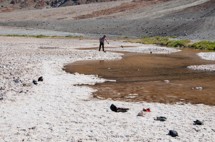
The walk into the basin is on a self-maintaining trail, where the salt has basically crushed down to form a soft base that people follow as far into the flats as they want to wander. Not many people want to wander off of that trail by the looks of it, and I imagine the surface would be quite sharp and unsteady if you did.


It was getting hotter, so I headed back to my truck and followed the signs to the Artist’s Drive, which is a “don’t miss” part of the park that takes you on a nine mile, one-way road through dramatic and colorful volcanic and sedimentary hills. It loops off of an back onto the road to Badwater, and you can approach from either direction as there are turnouts to let people coming the other way pass by.
After a stop at the Visitor’s Center, I headed back to my camper to try and avoid the midday heat, but discovered my generator setup wasn’t going to work with the tools I had on hand. I was getting increasingly hot and cranky, so I decided to pack it up and head out in order to break up the drive from there to Yosemite, which was my next destination. The drive out of Death Valley is quite something! The road winds up over the Panamint Range, and the view of the valley below is stunning, with the Panamint Dunes off in the distance. This is also the region of the park where “The Racetrack” is, with it’s mysterious moving rocks.
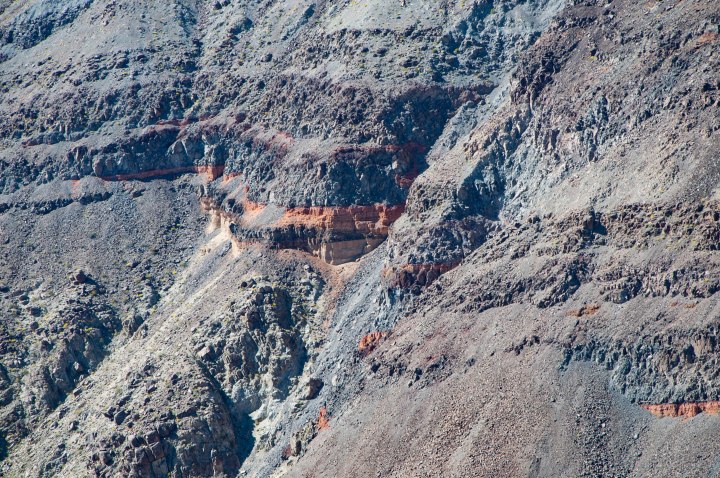
 I made one final stop on the way out of Death Valley to see the black lava and red cylinder cones that are part of the dramatic volcanic landscape that makes up this part of the park. Beautiful.
Overall impression: The dryness of this area was actually much more difficult for me to manage than the heat, but I’m so glad I was able to spend even a day here. It’s beautiful and rugged and fascinating. I would love to return and visit one of the other park regions, especially the area up around The Racetrack.
Costs: My no hook-up campsite at the Furnace Creek Campground was $18 for the night. Electric hookup sites are first come, first serve and I arrived late on a Friday, so them’s the breaks. Lunch at the Furnace Creek Ranch buffet was the only option, and the worst meal I’ve ever had in my life. It cost $16. It’s the only buffet I’ve been to where you pay as you come in (and I now know why), with no wait service at all. The hot table options were dried out chicken breasts with your choice of “alfredo” or marinara sauce, thin and dry pork of some kind, peas, mashed potatoes with lots of fatty something or another in them, and an assortment of wonder breads. There might have been corn. Seriously, don’t eat here. The safest option was a marginal salad bar featuring canned peaches and pears dotted with an occasional blueberry.
